Trip basis
- Departure::19/07/2022
- Arrival:24/07/2022
- Duration: 6 días
- Destination:Sierra Nevada
- Activity:Trekking
- Level:
- Mín-max group:4-10 participants
- Reference:22-158-TK-SP
Prices per participant
Price. 575 euros.
Kind of trip
Activity
Duration
Level
Season
Nº of participants
Place
Comfort
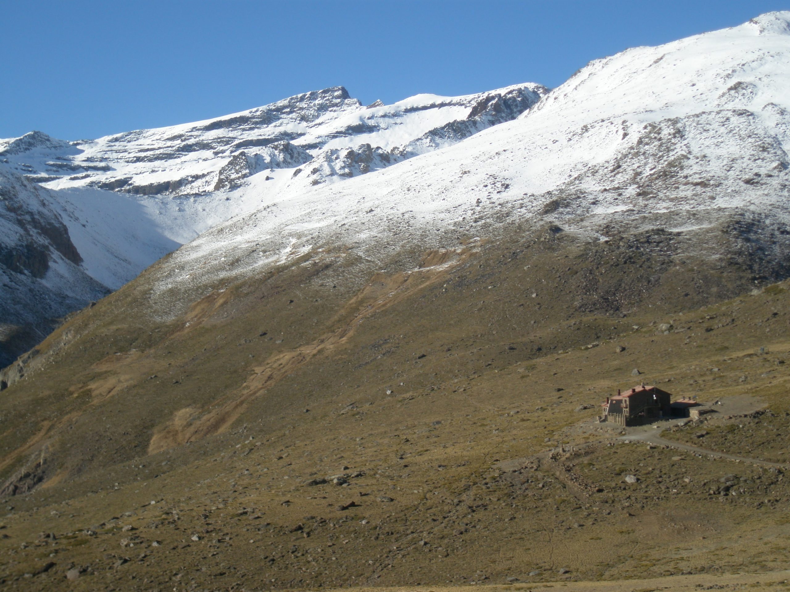
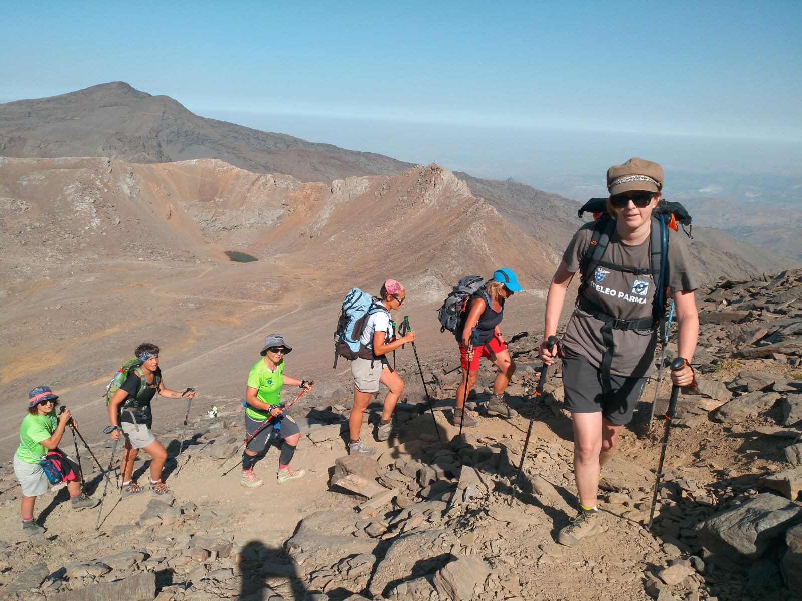
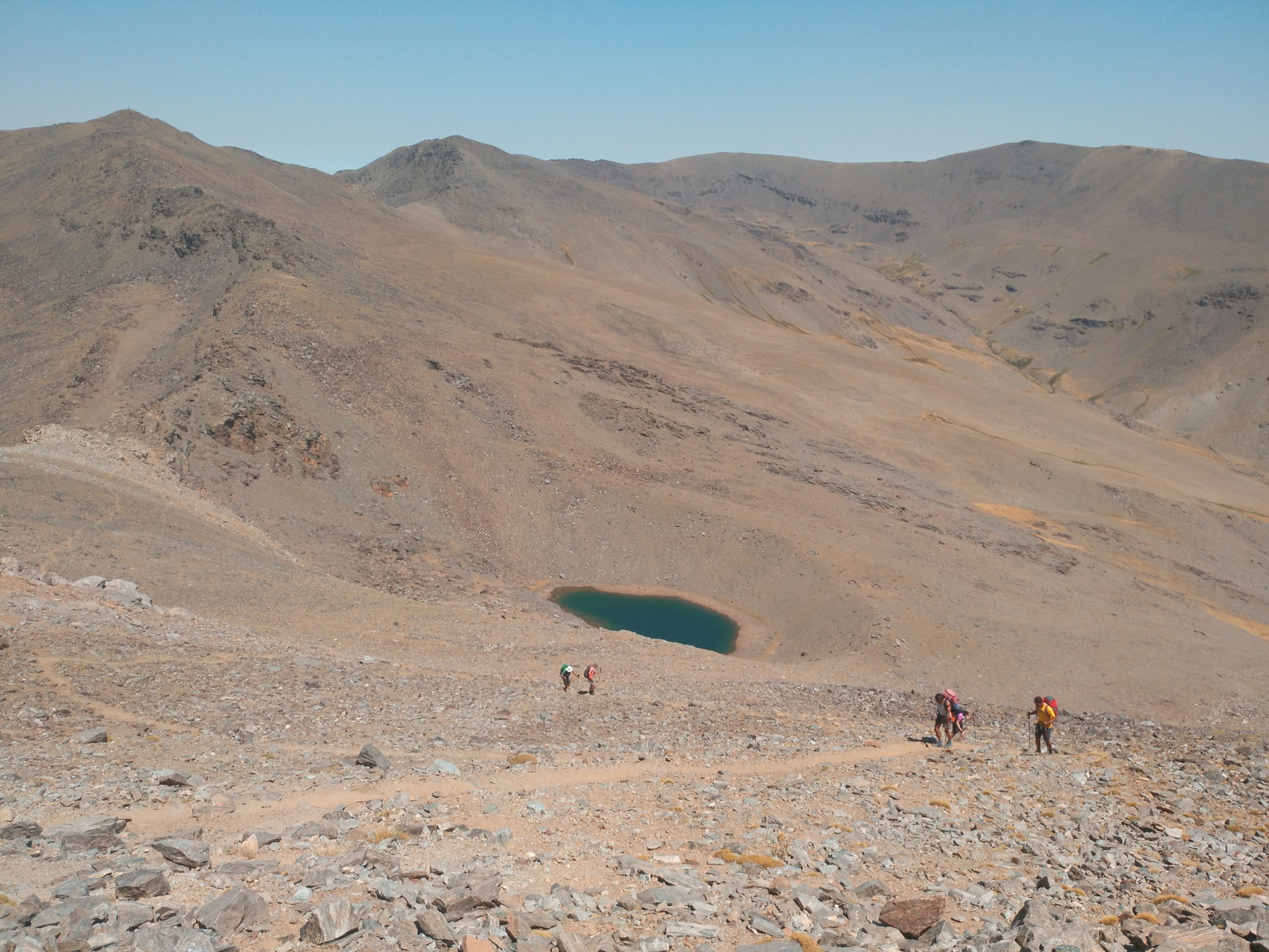
Welcome to the South. To the highest mountains of the Iberian Peninsula. To the southernmost mountain range in Europe. And to a snow kingdom with views overlooking the Mediterranean Sea. The Yabal Sulayr, or Monte del Sol (hill of the sun) as the Muslims called it when they ruled this land. If what you are looking for is the sun and good weather, you have chosen the right option. Sierra Nevada stands out for its great climate, although being a high-altitude route –we will be above 3000 metres in many occasions– we can never take the Sierra Nevada for granted. Steep climbs and legendary summits await us, as we ascend Alcazaba and Mulhacén, which at 3.428 metres, is the highest mountain of the Iberian Peninsula. As we walk, we pass beautiful mountain lakes that are considered one of Europe ́s botanical jewels, and uniquely give the Sierra Nevada twin protected status, as both a National Park and a Biosphere Reserve.
We will not only visit the most alpine area of the Sierra Nevada, but will have time to relax and enjoy the most famous white villages of Alpujarras, such as Capileira and Trevélez, where we will also taste the local delicacies like the “jamón serrano”(Spanish ham), and “plato alpujarreño”(Spanish fry-up!). Just thinking about it makes our mouth water…
These are amongst the highlights of our HI TREK SIERRA NEVADA, a high circular trekking route in the Sierra Nevada Natural Park, located in Andalusia, in the south of Spain. This circular 114km route is a real challenge, with a total elevation of 7.680m, and an even more vertiginous descent of 8.500m.
Sierra Nevada is a mountain massif located in the Penibetico mountain ranges. It is located in Andalusia, covering the east-central area of the region of Granada. It is the Western Europe’s highest mountain massif after the Alps. Its highest point is the Mulhacen Peak, with 3.482m.
Sierra Nevada, along with the Betic ranges, was formed during the alpine orogeny in the Tertiary era. Due to its isolation and altitude, since the end of the Würm glaciation, the massif has remained as a refuge to countless plants and endemic species, not normally found in Mediterranean latitudes. There are 66 endemic vascular plants and another 80 animal species, which represent the greatest biodiversity in the Iberian Peninsula and Europe.
Called "Sierra of the Sol", by the Arabs, it has a rich cultural and historical heritage with Roman, Visigoth and Tartesios remains.
The most significant of the Muslim period are the sophisticated irrigation techniques, whose ditches and brooks plow the slopes collecting melt water and runoff to be harnessed in traditional uses and activities.
The city of Granada boasts a unique cultural and artistic heritage like the Alhambra, the interesting Albahicín and the Calderería, as well as many other places that we will explore.
The good food deserves a mention, so they have the traditional “tapas” offered for free with each drink and many of them are quite succulent and creative. This habit extends all over the region of Granada and its villages.
The famous and attractive Alpujarra is another place to get lost and enjoy its mountains, its landscapes, its gastronomy, wines and people.
Motril, Salobreña or Almuñecar are only half an hour away from Granada and they are an interesting alternative to complete your holidays spending a couple of days at the beach.
It is important to carry little weight in the backpack to walk comfortably, so it is recommended to take only the essential material and clothing. Each day you may wash some laundry by hand and you do not have to carry food. We will inform you so you backpack weighs no more than 6-8 kilos.
Date Flexibility
Aside from the regular travel trip dates, we are flexible to reconsider new dates if those are more convenient to the client’s leisure plans. Do not hesitate to contact us should you have any different dates in mind.
Time and meeting point
One week prior to the trip departure date, an email will be sent to each participant to give away the meeting point and time along with the guide contact information. At this point any information considered essential to the trip organization will be shared.
Plane tickets (if applicable)
If case you wish us to handle you plane ticket, please contact us with airport arrival and departure details and number of needed luggage. Before issuing any ticket, Price and details Will be send to the client for its approval.
Muntania fee for plane ticket management is 20€ per person.
If, otherwise, you handle your plane tickets, please coordinate with us before hand to check on arrival and departure information.
Please take into consideration getting with you on your carry-on luggage some set of clothing in case of checked luggage lose.
Trekking Backpack
Very important to carry out just indispensable material and clothing to walk at ease. You would not need to take food supplies and clothing can be hand-wash daily. We recommend backpack weight between 6 to 10 kg.
Insurance policy
Extra insurance coverage with cancellation option, will allow you or a family member, in case of incident, to get back the total paid amount (or a percentage if you are already travelling) either for plane tickets or any trip service you might have hired. Moreover, through this coverage home return expenses will be taken care of.
Intermundial insurance company is our supplier for extra coverage insurances; thanks to the signed agreement between parties, Muntania gets to offer lower prices than handling directly with them. The travel insurance with cancellation option offered by Muntania will covered up to 900€ for national trips and 2000€ for abroad travel. In case your total trip cost is higher than the given coverage limit, an extension is always possible (please consult).
Other topics
No need for sleeping bag but requested a silk or cotton sheet bag.
Price. 575 euros.
Price. 575 euros.
Price. 575 euros.
Day 1. “Gaining height”. Jerez del Marquesado - Postero Alto hut.
Jerez de Marquesado is located in the high plateau of Zenete, at 1.200m in the province of Granada. The stage starts in the village where we will follow a path, always ascending, to reach the Postero Alto hut. It is a first contact and approaching stage.
Distance: 7 km. Elevation gain + 670m - 35m Time: 2 hours
Day 2. Postero Alto hut - Poqueira hut
It is a demanding stage due to the elevation and distance covered. In this stage we will test our mental endurance. We will start very early, with a firs ascent of 2-3 hours walking to Puntal de Juntillas, our first 3.000 meters peak of the tour, with an elevation gain of more than 1.000m.
From here, we will leave towards Alcazaba peak. The terrain is rocky and broken and the path goes up and down reaching some summits over 3.000 m high (Puntal de los Cuartos, El Cuervo, Puntal de Vacares....) The view over the mountain range is spectacular, with the Mediterranean Sea to the South and a north face with the view of Güejar mountain range. During the tour we will pass over some mountain lakes, remains of the ice age with popular legends about its origin, like Vacares Lake.
After 6 hours walking and reaching another 6 summits of 3.000 meters, we will detour to the lonely Stone of Yunque, at the bottom of the hill of Alcazaba. From here, we will take a comfortable path to reach the emblematic 7 lakes corrie, between the Alcazaba and Mulhacen Peaks.
From there we will make a little ascent before a long descent to Poqueira hut, where we could relax, stretch, have a shower and have a good dinner.
Variant through Basar de la Alcazaba:
It is a more alpine, demanding and exposed route, since it crosses the north face and it will be chosen depending on the weather conditions, timing and group.
Overstep the Puntal de las Calderetas and just before Goterón, we will take the north face of Alcazaba though the basar that cross it up at 3.100m. This route will take us to the col of 7 lakes between Mulhacen and Alcazaba towards the 7 lakes corrie. From here we will continue to Poqueira Hut as in the normal route.
Distance: 26 km. Elevation gain + 2.240m - 1.600m. Time: 10-11 hours
Day 3. The roof of the Peninsula. Poqueira hut - Mulhacen Peak - Albergue Universitario.
This is the day that we will climb the highest summit of the Peninsula, Mulhacen Peak with 3.478m and one of the important 3.000m peaks in Sierra Nevada, Cerro de los Machos, with 3.327m
The name of Mulhacen comes from the Moorish King Mulay Hacen, and it has one of the most popular legends of Sierra Nevada.
We will walk up the Mulhacén River to reach the Caldera bivouac hut, after passing through two beautiful mountain lakes. The track goes up to the Deer Col where we will follow a less busy route to contemplate the amazing north faces of the corrie, the Valdeinfierno canyon and the village of Güejar Sierra.
After reaching the summit we will go down to the Caldera bivouac through the normal route on the west face. We will pass over the Caldera Lake to get to Cerro Pelao where we will take a path until the entrance to the path leading to Cerro Machos. This ascent is short but intense. From here we will descent to Corrales de Veleta.
From this point and considering the accumulated tiredness, we have decided to use the High Summits Interpretation Service, a transport service that will save us from going down in 500m in altitude in just a few minutes.
Stretching time, shower and relax in a mythical hut of Sierra Nevada where we will enjoy the good atmosphere and a good dinner.
Distance: 21 km. Elevation gain + 1.480m - 1.550m. Time: 9-10 hours
Day 4. Albergue Universitario-Veleta - Alpujarra and Arab system of Canals - Capileira.
This is a long and uneven stage. We will pass from the north to the south slopes of Sierra Nevada, ending at the Alpujarra area.
We will leave Albergue Universitario to go up the Veleta Peak (3.390m) with amazing views. We will descent to Carihuela hut before starting a long descent towards Capileira through Loma Púa at 1.430m high. During the way we could see the Amoladeras Arab Canals and the New Canal.
Distance: 20 km. Elevation gain + 1.200m - 2.200m. Time: 8-9 hours
Day 5. “Touring the Alpujarra though the Sulayr”. Capileira - Trevélez.
In this stage we will make a tour of the Alpujarra, we will go from the village of Capileira to the village of Trevélez at 1.470 m high and very famous for its ham. One part of the tour will be trough a very representative path in Sierra Nevada, called “The Sulayr”.
It is a comfortable and not difficult stage, but considering the distance and ups and downs is not a resting stage.
We will leave Capileira towards the leisure area of Hoya del Portillo, one of the parking areas to get the Mulhacen or Poqueira hut. In this section we will also pass two important canals: Acequia Alta and Acequia del Medio.
After crossing a couple of interesting canyons, we will take the Trevélez canyon to the Trevélez camping (1.530 m), located at the village entrance and where we will have another nice accommodation.
At this point of the trip the tiredness is clear, so we have chosen a comfortable rural hotel with swimming pool. A well-deserved treat to ourselfs.
Distance: 17 km. Elevation gain + 1.050m - 1.035m. Time: 6 hours
Day 6. “From Alpujarras to Marquesado”. Trevélez - Jérez del Marquesado.
A long stage that will take us back to Jérez del Marquesado (1.200 m), closing the circular route and ending the trekking at the starting point.
We will leave the village through the Trevélez River Canyon, following at some points the New Canal and the Royal cattle Track of Trevélez. In the confluence of the canyons we will take the Sabinar Canyon towards the Meseta farmhouse from where we will ascent to the mountain pass of Trevélez at 2.800 m.
From this mountain pass we will descent through the path we took in the second stage to the Postero Alto hut at 1.800m
By the group´s prior request, the guided route could finish at the Postero Alto hut, to spend the night and descent independently next day to Jérez del Marquesado so you would have the whole day for the return trip. There is also the option of accommodation at Jérez del Marquesado and start the return trip also next day.
Distance: 25 km. Elevation gain + 1.850m - 2.100m. Time: 8-10 hoursía